Wednesday, September 14, 2011

A definite touch of fall out there this afternoon with 2PM temperatures only in the 50s (South)/60s (KC North) around the area...all thanks to a push of modified arctic air that has quickly moved into the area...it does appear that today will be the first day with highs in the 60s since May 28th @ KCI, assuming we don't pop another 5 degrees...you can feel the seasons changing out there...but it is temporary as a return to much warmer weather is likely later next week. Yesterday Springfield, MO hit 99...today they're in the upper 50s...and some more wonderful late summer/early fall weather days are appearing more and more likely as we finish off the summer season.

This airmass was born over the far NW territories a few days ago and should set record lows across the upper midwest and perhaps the Great Lakes areas over the next couple of mornings before the airmass moves away. Freeze warnings are in effect for almost all of MN, ND and parts of WI, SD, and IA. While we shouldn't see frost around the metro, it's not out of the question that there could be some very patchy front closer to the IA border area...dewpoints in the central plains states are in the 20s and 30s from the I-80 corridor northwards and with clear/clearing skies and lighter winds, a chilly night is certainly in store for a large part of the area...the record low for Minneapolis/St Paul is 36 for THU and 38 for FRI...those should easily be broken...this is very early for them to have a freeze...here is a map from the NWS in MSP showing the median 1st freeze dates...for the MSP area it's October 1st-10th.


Just as an FYI...for the KC area our 1st freeze on average falls towards the 3rd week of October...

Over the last 10 years here are our 1st 32 or below days @ KCI...

2010:  10/29
2009:  10/18
2008:  10/27
2007:  11/1
2006:  10/13
2005:  11/10
2004:  11/12
2003:  10/26
2002:  10/13
2001:  10/27
2000:  10/6

Of course this varies quite a bit in the rural areas...the NWS in Pleasant Hill has a web page dedicated to this...go here for more information.

Overall the cool weather will last for the next several days...tomorrow looks fine with highs again in the 60s then there is the issue of what happens as the cool airmass starts to move away and warmer air aloft (at the beginning) starts to move in. The air is not only cool but will be rather dry, this may prevent much in the way of rain to make it to the ground. There will be a lot of clouds in the mid levels on FRI moving through, and there is a chance for at least some sprinkles in the area...somebody will probably get a few hundredths but the air below 7-8000 feet will be pretty dry so a lot of whatever falls may evaporate before it reaches the ground. The models typically don't handle these scenarios well...but it's tough at this point to imagine anything of significance moving on through.


There will be an additional wave in the mid levels moving through on SAT...I can see this one being a bit stronger and I do think the rain chance on SAT is better than FRI...don't think it would be anything more than a few hours worth...but the potential is certainly there for something in the AM on SAT...the American Royal Parade is SAT @ 10AM...I'll be there with StormFox, so I'm hoping I don't need to use the windshield wipers.

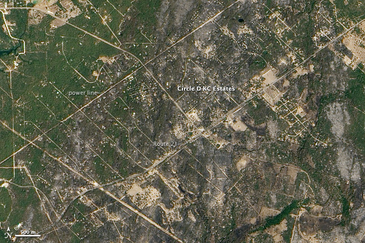
Needless to say it's been very dry around the metro this month. In KS the summer drought has cost upwards of  $1.7 Billion dollars. Recently you heard of another batch of devastating fires in TX...here is a satellite photo showing the burn scar left over from these terrible fires...


Today in Atlanta, it was another 90+ day for the 90th time this year...this ties the record set in 1980. Yesterday Dallas hit 100+ for the 70th time for a record and Wichita Falls hit 100+ for the 100th time, another record. Houston yesterday hit 102 for the latest on record...so this year they hit 102 the earliest and the latest on record. Here is another graphic showing some the the extreme heat in SE TX...


Not a lot of rainfall is expected down there for the next couple of weeks.

Have a great rest of the week.

Joe

Friday, August 26, 2011

Another comprehensive weather blog for you on this beautiful TGIF afternoon in the region. We'll talk about our weather, with a disturbance possible on Sunday PM and of course the latest on Irene.

1st topic is our weather...great out there right now and it will remain that way through the first part of the weekend. High pressure which built in yesterday is keeping the air nice and dry...dewpoints are reasonable for late August (lower 60s) and the winds are light out of the S/SSE...in other words about as good as you can ask for. While we continue to evaporate all that rainfall for the last couple of weeks...areas farther SW, away from KC are certainly drier and that is reflected in the temperatures and the dewpoints...here is the 2PM weather map...the numbers in GREEN represent the dewpoints...notice they're in the 40s(!) to the SW of KC...


Over the weekend, the issue we'll have, as we finish the weekend, is the pesky NW flow that again is an issue for us...I haven't had much luck with timing the rainfall in these situations (i.e. this past MON) so things may happen a bit faster than I'm shooting for...but as you can see from the map below, there is another wave crossing the Rockies and moving into the Plains SUN AM...this should ripple our way and at least give us the chance of storms moving through quickly SUN PM/Evening. It's possible they may be east/west of the metro, but I won't be able to figure that part out till SUN AM so I just want you to be aware of the potential for something after lunch on Sunday.

After that we should be fine for of next week with a quick shot of heat likely into next THU...perhaps another 95-98 run for highs ahead of some sort of front for later in week. The latest EURO brings a decent front through next weekend, the GFS really doesn't have much.

Before I get to Irene...I wanted to touch on the heat down across the Southern Plains...I dug this up today from NOAA...this is through yesterday in terms of the numbers...just incredible in the big scheme of things.

So far today, at least Dallas and Oklahoma City are near to above 100, as well as most of N TX and S OK. Houston is @ 99 as I type...crazy indeed!

OK, lets get to Irene...I've always been fascinated with the tropical aspects of Meteorology. My senior project was a research paper into Hurricane Allan from 1980 that was an amazing storm in the Gulf Of Mexico. Anyway...here is the latest.

The storm is healthy but not a "Katrina" storm. It has held it's own today, going through various waves of slow intensifying and then decreasing a bit in strength. One thing that needs to be pointed out is the wind field. the pressure of the storm started dropping yesterday evening...however the winds around the hurricane didn't increase in intensity...however they did broaden out. At this point tropical storm force winds (38+ MPH) go out about 450 miles from east>west...basically the distance from the KC area to almost Indianapolis. Hurricane force winds (74+ MPH) go out some 130 miles from E>W or roughly the distance from the KC to Abilene, KS...so the scope of the storm is very large. Take a look at it...


Moving northwards @ about 15 MPH...should make landfall near Morehead City, NC sometime tomorrow AM then move through far eastern NC during the day tomorrow before coming up the NE seaboard. Winds are near 100 MPH...the strongest winds, if you were to draw a line right through the center of the storm from the N>S are on the right hand side of the storm...the "weaker" winds are on the left hand side of the storm. Here is another way of explaining that...from boatus.com

Here is radar showing the storm...as of this writing look down to the bottom of the screen, you can see a circular, clear area..this is the eye...it will become more and more vivid over the next 12 hours as the storm gets closer tot he radar sites.


The track of the storm by SUN AM takes it near or maybe about 50 miles east of NYC...this may reduce the strongest winds in the NYC area, and also knock down the storm surge somewhat. But there are concerns about the storms timing and also the time of the highest tides. Today the Mayor order the evacuation of some low lying areas...some 250,000 people. Reports indicate that this is the 1st time that has been ordered. Also mass transit is closing down tomorrow @ noon in the NYC area. On the assumption that Irene makes landfall again near central Long Island...the biggest issue for that part of the country will be flooding rainfall and 40-70 MPH winds...take a look at how much rain the NWS is projecting for that area...


1000 flights have been cancelled so far for the upcoming weekend. Odds are, much like some of their blizzards for the past couple of years, it'll take a few days for all of this to settle back down from a flight situation. Obviously if you're more interested in all the human effects of this, check in with the NY Times, NY Daily News etc for more information.

That'll do it for today, I've got a lot planned for you this weekend in my Irene coverage. By the way...to answer the FB quiz question...5 years ago on Monday Katrina hit the Gulf Coast.

Joe

Thursday, August 25, 2011

What a wonderful day around the area as temperatures are in the lower 80s now and skies are perfectly clear. This great weather, of course, is in contrast to what the folks in the SE part and NE part of the country are dealing with and watching as I type. Of course Irene will be the focus of this weather blog.

I haven't been overly impressed later this AM and PM with the "look" of Irene. While radar is showing the eye of the storm...recon reports indicate that the eye is ragged and "open" across the southern and western parts. This tells me that for whatever reason, Irene is not as "healthy" now as it was yesterday at about this time. Recon reports also so the winds in the 90-105 mph range and have been doing so for the last several flights. The eye of the storm, which was a tight 15 miles across has broadened to 35 miles across which is NOT a sign of a healthy hurricane...which is a good thing for the Eastern Seaboard. Whether the interaction with Andros Island in the Bahamas or perhaps some weak shear and/or perhaps even some dry air circulating into the storm...something is and has been going on today with the "look" of the storm in my opinion.

Regardless of all that, the storm is a large one and the wind field last night was expanding in scope, perhaps not intensity but size and width. This is what I'm talking about...notice the wind speeds around the storm...this from boatus.com


Click on that graphic to make it more readable. The satellite photo this afternoon shows that this hurricane is definitely eastern oriented...


The "official" forecast track hasn't really wavered that much, perhaps though leaning back towards the west over the past 24 hours or so...


The NE part of the country is watching this like a hawk, because this is becoming more and more like yet another billion $ weather event, and the metropolis's back east may really bear the brunt of the flooding and wave action along the coastline. Rainfall itself may be astounding...I got up to about the 10" contour and stopped counting...


In terms of model forecasts...they still seem to be making another landfall point being somewhere along Long Island, NY...or perhaps even hugging the coastline up to NYC from the Delmarva.


This brings into play the MAJOR issue of flooding for the NY area. In Philadelphia, they just broke their August rainfall record with over 13". This without even a single drop of rainfall from Irene. Mayor Bloomberg of NY will decide tomorrow whether or not to start evacuations from what is referred to as Zone A, those most subject to flooding from any urricane...I like to look at this map to get an idea where they're thinking about evacuating. The city breaks down their evacuations into zones...

  • Residents in Zone A face the highest risk of flooding from a hurricane's storm surge. Zone A includes all low-lying coastal areas and other areas that could experience storm surge in ANY hurricane that makes landfall close to New York City.
  • Residents in Zone B may experience storm surge flooding from a MODERATE (Category 2 or higher) hurricane.
  • Residents in Zone C may experience storm surge flooding from a MAJOR hurricane (Category 3 & 4) making landfall just south of New York City. A major hurricane is unlikely in New York City, but not impossible.

Here is a timely article about how vulnerable NYC is to something like this. Think about the flooding, all the underground stuff (subways) etc that would be impacted by the water. It really is amazing the potential disaster that may unfold. Obviously a lot can change, Mainly the question I have is how strong will this thing really be, in terms of wind as it gets up there. That is connected to the exact track it takes, farther inland and the wind aspect is reduced, however the rain amounts would still be extreme unless the storms speed increases dramatically which isn't expected till it passes through New England. The latest EURO came in with an initial landfall near Morehead City, NC...then to near Plymouth, NC...then right up the coastline towards Atlantic City, NJ, then weakening as it passes over NYC. This track, should it verify would be really horrific assuming the storm maintains CAT 1 status as it moves northwards. Also there has to be consideration for all the high rise buildings, and the potential for glass breakage. The farther up you go the less friction there is and the higher the likelyhood of building damage. Remember Katrina back in '05 and the hotel that was hit by the winds...here is a picture to jog your memory...


Something like this MAY occur in the NYC area, depending on the intensity of the winds with the track portrayed by the EURO. Farther east and the winds won't be as severe...still in the 50-70 MPH range.

Expect the entire NE part of the country closest to the coastline to close down this weekend.

Joe

Here is the latest about Irene...

SUMMARY OF 1100 AM EDT...1500 UTC...INFORMATION
-----------------------------------------------
LOCATION...25.9N 76.8W
ABOUT 75 MI...115 KM NNE OF NASSAU
ABOUT 645 MI...1040 KM S OF CAPE HATTERAS NORTH CAROLINA
MAXIMUM SUSTAINED WINDS...115 MPH...185 KM/H
PRESENT MOVEMENT...NNW OR 335 DEGREES AT 13 MPH...20 KM/H
MINIMUM CENTRAL PRESSURE...951 MB...28.08 INCHES


Hurricane Watches are in effect along the NC Coastline...and these will be expanded farther north before the night is done...


The folks from AccuWeather have put together a good compilation of the effects of Irene...

More later...

Joe

Thursday, August 18, 2011

T/Storm chances are the topic of the weather blog this afternoon, as well as other tidbits for you on a Thursday..good afternoon and thanks for reading, whether through Facebook, or through the website...

So let's talk storms...there is a large developing area of storms right now across and north of the I-80 corridor from near Omaha eastwards towards the north of Des Moines. The storms are racing towards the ESE and have produced some larger hail and gusty winds...and severe weather is possible in that area southwards to the NE and IA borders...here is a summation of the area of concern to the north...


These storms will continue to evolve and change over the next 6 hours...and a Severe T/Storm Watch is in effect for areas north of MO...


The storms will continue to develop farther off to the SW over the next 6 hours and those storms may get here towards or after 10PM for the metro or thereabouts from the NW to the SE...The SPC is also watching a corridor along the MO River for the potential of severe weather...one issue with how far SW the storms will form is the CAP which is trying to increase in strength across the Plains states and even closer to home across C and E KS...so this is certain a tricky forecast...


This includes the entire FOX 4 viewing area...

Again as these storms evolve they will generate a rather large cold pool that will surge to the SSE to SE over the next 6 hours or so...that pool should help to fire off new storms as it acts as a cold front that should move close to our area. The question that needs to be answered, and will be by 8PM I think is how much development takes place tot he SW of this original batch of storms. As is, strictly by looking at radar at this moment, it looks like a lot of the activity may barely clip the metro and pass mostly off towards the NE of the metro with the potential for 1-3" rainfall in addition to the storms. Also whatever surface boundary makes it to the area, will be overrun tomorrow early AM by an increasing low level jet that should spark off additional storms...

A lot of the parameters in the atmosphere favor a quick hitting shot of decent+ storms for the metro....including the high dewpoints, the amount of moisture in the atmosphere (PW's), the high CAPE values (instability in the atmosphere) in E Nebraska that's waiting to be tapped. That area will be a key tot he metro getting bigger storms/rainfall. That will be the area that we watch the most for development. Should things really get going in SE NE...then the metro is more in line with future rainfall, should nothing happen in that area, the worst may pass to the NE of KC.

Another opportunity for storms will develop tomorrow late night into SAT AM...although the bulk of the weekend looks to be dry I believe with highs in the 80s for the most part.


Other items of note include ANOTHER stage collapse, this because of (shocking) t/storm winds. This one occurred in Belgium. At least 4 so far are reported dead.

The tropics are still alive this afternoon. We've had 7 named storms so far in 2011 and Harvey would be the next named storm. At it may be trying to develop now across the Caribbean.


It's a small system and is moving from the W>E and appears to be more of a threat, should it develop more to the Central America area...area #2 which doesn't look impressive at this point...if forecasted by the longer range model guidance to potentially become the seasons first hurricane sometime next week somewhere int he Caribbean. We'll see about that.

Oklahoma City today had their 47th day this year with highs of 100+...the record is 50 back in 1980. Seems very doable, perhaps sooner rather than later. The NWS has issued an Excessive Heat Watch for parts of E OK through the weekend...as another run of 103+ heat is possible there, combined with dewpoints that will send the heat index to near 110+...

Meanwhile in addition to the heat in OK...look at this nasty heat in TX, that really has never broken.


The RED numbers are the temperatures and the GREEN numbers are the dewpoints. Houston and College Station are on track to have their HOTTEST August in recorded history. They set a record LAST August...and should break it this August! Pretty darn impressive!


That's it for now...

Joe

Monday, August 15, 2011

Well, I'm not totally surprised that it rained today, I'm rather shocked that it has persisted as long as it's done so and also that it turned into a great soaking rain for the metro as well as others in NE KS and far W MO...

Last night I thought the best chance of something like this happening was to the NW of C...even showed a map highlighting the area I thought was most vulnerable to something like what happened today.. That map did not include the metro...I only had a 20-30% chance of some rain today. Timed out the rain perfectly but again not a very good forecast for the KC area at all. Rainfall amounts in the region were in the neighborhood of .25 to .75" or so...with a few areas closing in on 1"+. Here is a look at the doppler estimates from the NWS radar in Topeka...I'm still hesitant to show the radar data for indicated totals from Pleasant Hill because I think it's still running to high...


Ground truth is next...several views for you through John, Jackson and Platte Counties...


Now let's move a bit farther northwards...


From the airports @ 1PM here are the totals...

KCI: .61"
Downtown: .47"
Olathe: .68"
Gardner: .35"
Lawrence: .46"
Topeka: .74:
Lees Summit: .35"
Sedalia: Trace

A great soaking rainfall...

We'll continue to have opportunities almost all week long. I don't think it will rain every day though, but in this pesky NW flow, any little disturbance will create rainfall and the air will be getting more saturated over the next few days. We never really get totally capped either...so it's going to be a tricky forecast for the next 5 days or so...

The heat will also be lingering to the south, although not to the extreme as previous weeks, it's still there and will creep farther northwards as the week moves along. Notice the temperatures tomorrow towards southern KS...


Now take a look at Wednesday...


Again notice where the heat is...just across S KS and OK...sitting there. I still think we'll nibble one more time into that airmass for a few days but for the time being it looks like the persistent ridge/dome of hot air will gradually push back out through the Rockies and Western 1/3rd of the country in about a week or so. This will create more problems out there because the monsoon season hasn't been as productive as hoped for for AZ and NM...and this certainly won't help the cause at all.


Finally onto the tropics where Gert has moved towards the east of Bermuda and will continue out to sea...Gert is the 7th named storm and so far not one hurricane this season out of all of them. As I mentioned over the weekend...even if Gert becomes a hurricane, in the 6th previous storms this year, they too hadn't become hurricanes...for that number of storms (6) that had never happened before. In other words by the time you got to the "G" name, you always had a hurricane...so this is unusual indeed!


That's about it for today...have a great week!

Joe


Tuesday, August 9, 2011

6PM Update+++++++++++++

Latest models are showing a good soaking rain for tomorrow...the key area to watch later tonight is the western plains were another complex of storms should develop and roll our way....these NW flow situations are pretty tricky and color me somewhat impressed by the ripple that will rapidly increase the clouds this evening and may create a few showers after 8PM or so, especially on the KC side...here are some of the totals of the NAM...1st the 12Z run...


Now here is the 18Z run...


My forecast for the metro is widespread .25-1" rainfall...areas farther NE away from KC will see less...and areas to the SW of KC may see .75-1.5" of much needed rainfall...

Let's keep our fingers crossed!


asf

Friday, August 5, 2011

Even though it's my day off, I thought I'd write up a special weather blog for you as I observed another interesting day along the MO River up across NW MO yesterday...the flooding continues up there but the waters are SLOWLY retreating...but for the foreseeable future flood warnings will continue up there.

I thought I'd show you a couple of perspectives with the view from space. First is showing you the look of the river from last year...


Now look at a picture from a couple of days ago...notice the expanse of the river!


It's really glaring the largeness of the River across NW MO...in spots still more than several miles across.

If your a regular reader of the blog, you may remember about 6 weeks or so ago, I observed that the MO River, with such dramatic flooding, was actually changing the weather to a small extent across a small area of NW MO and SW IA...it happened again yesterday. Let me show you another perspective with a simple black and white satellite picture...


The area of focus is in the boxed region...notice, if you click on the image to make it larger, that we have cumulus clouds forming in the heat of the afternoon. However if you look closer...you can see a region of cloud free skies that is roughly co-located with the expanded MO River. This is a direct result of temepratures in the atmosphere being a couple of degrees cooler than the surrounding land areas that have heated up more. As a result of the additional land heating there are more and stronger pockets of rising air, since the land heats more efficiently than water areas. Without those stronger pockets of rising air, the water areas are more cloud free. This is actually a rather common phenomena over larger lakes, for example the Great Lakes area. Pretty cool stuff!

Yesterday was another scorcher, and today is going to follow suit as well...here are some of the record highs yesterday...notice how close the searing heat is to the metro...just about a 3 hour drive south and the dewpoints drop and the temperatures soar.

Joplin - 107°; OKC - 110°; Tulsa - 111°; Fayetteville,AR - 107°; DFW - 107°; Waco - 106°; Austin Mabry - 106...all impressive...

Ft Smith in AR has had 3 stright 105+ days...which I don't think has ever happened before...odds are today will make it 4 straight.

DFW (Dallas) as well as Waco have a hot run of 105+ going as well...take a look!


Click on the image to expand that so it's more readable.

Meanwhile the heat from July is still stirring some interest...here's some information regarding the amount of heat that was recorded...it's a different way of viewing things...


From NCDC...

How hot was the month of July in 2011? So hot that just by plotting the location of each daily heat record that was broken, a nearly complete image of the contiguous United States is visible. Almost 9,000 daily records were broken or tied last month, including 2,755 highest maximum temperatures and 6,171 highest minimum temperatures (i.e., nighttime records). It should be noted that the tally of records collected so far is not complete – more are expected to come in as station data from across the U.S. is mailed to the National Climatic Data Center. The statistics reported here only include weather stations with real-time electronic reporting, which accounts for about two-thirds of the locations. Final numbers should be available later in August.
This image plots how many times a heat record was broken or tied in a given location. Some cities reached daily high temperatures 19 out of the 31 days in the month. The largest concentration of these records occur in the southern Plains, Midwest, and Northeast U.S., which were gripped by a series of heat waves pushing heat indices well into the 100’s (Fahrenheit) for many days at a time.
Temperature records are based on historical data from NCDC’s Cooperative Summary of the Day data set and the preliminary reports from the Cooperative Observers and National Weather Service stations around the country. All stations have at least 30 years of data upon which these records are based.


Well that's it for today...a more active and potentially stormier pattern is shaping up for next week...perhaps as early as Monday AM...watch Karli for all the forecast updates this weekend!

Joe
Well most of the region saw some much needed rainfall this AM...as a complex of t/storms marched across KS overnight. We showed them to you on the news last night as they were forming, the question in my mind at the time was whether or not they'd survive the 300 mile journey across the state with very little in the way of favorable inflow allowing them to sustain themselves. I'm glad I kept at least the chance of rain in the forecast this AM, but much like WED night I didn't want to over promise a bunch of rain...I'd say this time we got more coverage than I expected.

Now since we're dealing with t/storms...there are usually haves and have nots...and in the case of this AM that also is true...here is some rainfall information from some of the gauges around the metro...


and a bit farther northwards...

Click on those images to make them larger and more readable to to see how much you may have picked up...

The official airport tallies weren't overly impressive...KCI, officially for KC, got .11"...Downtown had .08", Lees Summit had .38"...Gardner had .43"...Whiteman AFB had .32" and Sedalia had .58"...those totals are between 7AM and 1PM...

Here are the doppler estimates...one has to be somewhat saddened by the rapid decrease in totals as this complex moved towards KC...notice the totals really fading east of Manhattan...

Latest model data is showing the potential for another convective cluster to move into the region MON AM...with the potential for heavier rainfall. there may be some scattered activity as well SUN AM in parts of the area...

Overall though the weekend looks OK with highs in the 90s, especially SAT....

Meanwhile, as I was crunching the stats for the month of July, and trying to understand why my power bill was so high last month...I came up with these numbers...did you know that for Average HIGHS in July, we were the hottest we've been, since July of 1980. Whenever your comparing things to 1980, you know that's impressive. Our average high was 92.9 degrees...back in 1980 just to show how hot that month really was the avg high was over 97 degrees...think about that...for as hot as July was, July of 1980 was 5 degrees hotter. Also the average AM lows were warmer this July than any other July going back to 1966...that is in large part due to the moisture/higher dewpoints that were affecting us until we baked out the soil a couple of weeks ago.


Meanwhile the core of the heat has settled just about a 3 hour's drive south of  KC...Dallas has hit 100 for the 35th straight day...

Here is some information from the NWS that they came out with this AM...again tack on another day to the 100s streak for today's high...


Have a great weekend and hopefully you'll stay cool!

Joe

Friday, July 29, 2011

A nice little break (at least for areas from I-70 northwards) thanks to a weak cold front that slipped into the region last night. the air is somewhat more tolerable this afternoon from a temperature standpoint and while the humidity/dewpoints are higher...it is a bit more bearable out there. Once you get on the south side of the metro, the relief is less noticeable as readings are now in the lower 90s and will tick up another few more degrees this afternoon. Harrisonville is reporting 95 degrees as of 1PM this afternoon whereas St Joseph is reporting 78 more pleasant degrees this afternoon. This weak front has just about fallen apart, and will continue to lose it's definition over the next 12 hours or so.


The rainfall last night was rather spotty. Some areas got pounded with torrential rains and heavy winds while many areas didn't get that much, if any at all. Rainfall totals were in the 1-3" range across NE KS...DO NOT pay attention to the doppler estimates from the Pleasant Hill radar, they have been WAYYYYY overdone for the last month+ or so. Here is the Topeka radar estimates...


Valley Falls, KS had 2.35" of rainfall...here is a map showing the ground truth reports of rainfall totals...


Click on that map to make it larger...

There were some damaging storms with the acticity that was developing around 6-7PM near the Greenwood area on the MO side...this picture was taken by Vince our IT guy...who was in Greenwood at the time of the storm...


There are still some showers up to the north of the KC area, helping to reinforce the "coolness" of the air up there.

Meanwhile Tropical Storm Don continues to head towards the S TX coastline. The rainfall will be welcome for sure with rainfall deficits down there int he area of 9-18". Anything would certainly be welcome. Here is the latest picture on Don...


It's holding it's own with winds of 50-55 MPH...despite some northerly shear. The future of the storm has been pretty well predicted and Don will continue a nice WNW movement. The speed of the storms motion will preclude crazy rainfall totals...


The folks from HPC have issued this rainfall forecast...not exactly widespread but at least some will get more than a good dousing from the tropical storm...


Back to our weather...we should get a bit more of a temperature break tomorrow with hopefully the addition of more widespread cloud cover and maybe some additional rainfall. We'll need to watch tonight for the potential of another cluster of t/storms developing a bit farther southwards compared to last night. The cluster may develop closer to the I-70 corridor off to the west of here...there is clearly a vort max across the western part of KS but it's barely moving...so there are a few players on the field for additional rainfall tonight and even through part of the day tomorrow...

After that we'll once again jump right back into the heat with the high humidity again until we bake out the air, which will happen early next week. 95-100 degree heat is likely SUN-MON with the downtown area and points southwards between 100-105. So we'll once again be back into the same oppressive airmass that has settled to our immediate south today. Sometime later next week we'll do the whole thing again with a reduction in the highs and at least some chances of additional rainfall.


Have a great weekend!


Joe

Thursday, July 28, 2011

The Grinding Heat Eases Off

I'm back...spent about a week in the Phoenix area visiting my mom and playing a lot of golf, well mainly playing a lot of golf. Overall about 6 rounds in 5 days...each day was about 100-105 with dewpoints in the 40s and 50s...barely sweated at all. On Monday AM, after some nice t/storm activity Sunday night, it was rather thick there with dewpoints near 70 or so. It lasted for about 6 hours before the desert sun started to dry things out again. Didn't see any haboobs, but the folks there are still buzzing about them. As a matter of fact there was a big writeup in the Sunday paper about the phenomena. Anyway I'm back which means it's time to start the weather blogs again.

In my absence I see I didn't miss much...l00 degree heat has become common around these parts and even when we get a "break", perhaps like tomorrow and Saturday, we still expect 90s in the region to be the norm. Hopefully we'll take off about 5-10 degrees compared to the last several days. Over this weekend I'll be doing some comparison stats for you showing how this summer is comparing to last summer. We were really in the heart of the summer heat last year at about this time and it continued throughout the month of August before finally breaking. We finished last August some 4.6 degrees above normal and it appears that this August will certainly start out rather toasty as another run of 100+ heat appears to be shaping up.

This again is being generated by our semipermanent dome of heat that is recycling again through the middle part of the country. This will once again intensify across the midwest early next week and you can clearly see the effects on the temperatures around 5000' or so...
Now here is the same map for later int he week...there is a suggestion that there could be another weak front trying to slide our way...this is very iffy at this point...

So when things get this slow, I'm always looking to talk about something else...and today we'll tackle the tropics where Tropical Storm Don, which formed yesterday has had a rough go of things...first take a look at the latest satellite picture...


It's basically a ball of convection with winds near the center at close to 45 mph. There should be some intensifying as the storm is over the open waters of the very warm Gulf Of Mexico and the folks @ TPC suggest the potential for 60 MPH winds. The storm is also undergoing some shear, which is like poison to a tropical system. While not tremendous it may be enough to keep the intensification below hurricane status. As far as where Don should end up...latest forecasts have the storm near or just north of Corpus Christi sometime early Saturday morning. This actually may be a good thing down there, as is often the case in drought situations, and they really need the rainfall, these things sometimes will ease with tropical rainfall. I think I read the other day that this part of Texas needed some 15-20" of rainfall to catch up. Systems like Don can help that IF they slow down, which Don probably won't do. Can't imagine how much, if any, moisture will head this way...the dome of heat will deflect the moisture well to the south of here and then take it into far W TX or Southern NM...so at this point it doesn't look that promising.


Also of note is the record rainfall that has fallen in Chicago, several days ago, and also in Dubuque, IA yesterday with some 7.47"...very impressive. It would not be unusual that when this heat finally breaks here that some big t/storm complex will be generated...

Today is the 14th straight day @ KCI and 15th straight day @ the downtown airport that we've busted through 90 or higher...

Have a great day and it's nice to be back!

Joe