Another comprehensive weather blog for you on this beautiful TGIF afternoon in the region. We'll talk about our weather, with a disturbance possible on Sunday PM and of course the latest on Irene.
1st topic is our weather...great out there right now and it will remain that way through the first part of the weekend. High pressure which built in yesterday is keeping the air nice and dry...dewpoints are reasonable for late August (lower 60s) and the winds are light out of the S/SSE...in other words about as good as you can ask for. While we continue to evaporate all that rainfall for the last couple of weeks...areas farther SW, away from KC are certainly drier and that is reflected in the temperatures and the dewpoints...here is the 2PM weather map...the numbers in GREEN represent the dewpoints...notice they're in the 40s(!) to the SW of KC...
Over the weekend, the issue we'll have, as we finish the weekend, is the pesky NW flow that again is an issue for us...I haven't had much luck with timing the rainfall in these situations (i.e. this past MON) so things may happen a bit faster than I'm shooting for...but as you can see from the map below, there is another wave crossing the Rockies and moving into the Plains SUN AM...this should ripple our way and at least give us the chance of storms moving through quickly SUN PM/Evening. It's possible they may be east/west of the metro, but I won't be able to figure that part out till SUN AM so I just want you to be aware of the potential for something after lunch on Sunday.
After that we should be fine for of next week with a quick shot of heat likely into next THU...perhaps another 95-98 run for highs ahead of some sort of front for later in week. The latest EURO brings a decent front through next weekend, the GFS really doesn't have much.
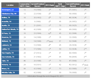
Before I get to Irene...I wanted to touch on the heat down across the Southern Plains...I dug this up today from NOAA...this is through yesterday in terms of the numbers...just incredible in the big scheme of things.
So far today, at least Dallas and Oklahoma City are near to above 100, as well as most of N TX and S OK. Houston is @ 99 as I type...crazy indeed!
OK, lets get to Irene...I've always been fascinated with the tropical aspects of Meteorology. My senior project was a research paper into Hurricane Allan from 1980 that was an amazing storm in the Gulf Of Mexico. Anyway...here is the latest.
The storm is healthy but not a "Katrina" storm. It has held it's own today, going through various waves of slow intensifying and then decreasing a bit in strength. One thing that needs to be pointed out is the wind field. the pressure of the storm started dropping yesterday evening...however the winds around the hurricane didn't increase in intensity...however they did broaden out. At this point tropical storm force winds (38+ MPH) go out about 450 miles from east>west...basically the distance from the KC area to almost Indianapolis. Hurricane force winds (74+ MPH) go out some 130 miles from E>W or roughly the distance from the KC to Abilene, KS...so the scope of the storm is very large. Take a look at it...
Moving northwards @ about 15 MPH...should make landfall near Morehead City, NC sometime tomorrow AM then move through far eastern NC during the day tomorrow before coming up the NE seaboard. Winds are near 100 MPH...the strongest winds, if you were to draw a line right through the center of the storm from the N>S are on the right hand side of the storm...the "weaker" winds are on the left hand side of the storm. Here is another way of explaining that...from boatus.com
Here is radar showing the storm...as of this writing look down to the bottom of the screen, you can see a circular, clear area..this is the eye...it will become more and more vivid over the next 12 hours as the storm gets closer tot he radar sites.
The track of the storm by SUN AM takes it near or maybe about 50 miles east of NYC...this may reduce the strongest winds in the NYC area, and also knock down the storm surge somewhat. But there are concerns about the storms timing and also the time of the highest tides. Today the Mayor order the evacuation of some low lying areas...some 250,000 people. Reports indicate that this is the 1st time that has been ordered. Also mass transit is closing down tomorrow @ noon in the NYC area. On the assumption that Irene makes landfall again near central Long Island...the biggest issue for that part of the country will be flooding rainfall and 40-70 MPH winds...take a look at how much rain the NWS is projecting for that area...
1000 flights have been cancelled so far for the upcoming weekend. Odds are, much like some of their blizzards for the past couple of years, it'll take a few days for all of this to settle back down from a flight situation. Obviously if you're more interested in all the human effects of this, check in with the NY Times, NY Daily News etc for more information.
That'll do it for today, I've got a lot planned for you this weekend in my Irene coverage. By the way...to answer the FB quiz question...5 years ago on Monday Katrina hit the Gulf Coast.
Joe


No comments:
Post a Comment