I thought I'd show you a couple of perspectives with the view from space. First is showing you the look of the river from last year...
Now look at a picture from a couple of days ago...notice the expanse of the river!

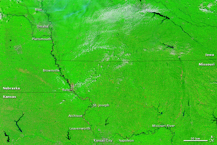
It's really glaring the largeness of the River across NW MO...in spots still more than several miles across.
If your a regular reader of the blog, you may remember about 6 weeks or so ago, I observed that the MO River, with such dramatic flooding, was actually changing the weather to a small extent across a small area of NW MO and SW IA...it happened again yesterday. Let me show you another perspective with a simple black and white satellite picture...

Yesterday was another scorcher, and today is going to follow suit as well...here are some of the record highs yesterday...notice how close the searing heat is to the metro...just about a 3 hour drive south and the dewpoints drop and the temperatures soar.
Joplin - 107°; OKC - 110°; Tulsa - 111°; Fayetteville,AR - 107°; DFW - 107°; Waco - 106°; Austin Mabry - 106...all impressive...
Ft Smith in AR has had 3 stright 105+ days...which I don't think has ever happened before...odds are today will make it 4 straight.
DFW (Dallas) as well as Waco have a hot run of 105+ going as well...take a look!

Click on the image to expand that so it's more readable.
Meanwhile the heat from July is still stirring some interest...here's some information regarding the amount of heat that was recorded...it's a different way of viewing things...

From NCDC...
How hot was the month of July in 2011? So hot that just by plotting the location of each daily heat record that was broken, a nearly complete image of the contiguous United States is visible. Almost 9,000 daily records were broken or tied last month, including 2,755 highest maximum temperatures and 6,171 highest minimum temperatures (i.e., nighttime records). It should be noted that the tally of records collected so far is not complete – more are expected to come in as station data from across the U.S. is mailed to the National Climatic Data Center. The statistics reported here only include weather stations with real-time electronic reporting, which accounts for about two-thirds of the locations. Final numbers should be available later in August.
This image plots how many times a heat record was broken or tied in a given location. Some cities reached daily high temperatures 19 out of the 31 days in the month. The largest concentration of these records occur in the southern Plains, Midwest, and Northeast U.S., which were gripped by a series of heat waves pushing heat indices well into the 100’s (Fahrenheit) for many days at a time.
Temperature records are based on historical data from NCDC’s Cooperative Summary of the Day data set and the preliminary reports from the Cooperative Observers and National Weather Service stations around the country. All stations have at least 30 years of data upon which these records are based.
Well that's it for today...a more active and potentially stormier pattern is shaping up for next week...perhaps as early as Monday AM...watch Karli for all the forecast updates this weekend!
Joe
No comments:
Post a Comment