A nice little break (at least for areas from I-70 northwards) thanks to a weak cold front that slipped into the region last night. the air is somewhat more tolerable this afternoon from a temperature standpoint and while the humidity/dewpoints are higher...it is a bit more bearable out there. Once you get on the south side of the metro, the relief is less noticeable as readings are now in the lower 90s and will tick up another few more degrees this afternoon. Harrisonville is reporting 95 degrees as of 1PM this afternoon whereas St Joseph is reporting 78 more pleasant degrees this afternoon. This weak front has just about fallen apart, and will continue to lose it's definition over the next 12 hours or so.
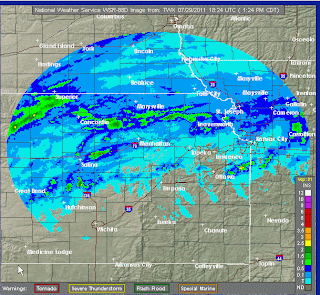
The rainfall last night was rather spotty. Some areas got pounded with torrential rains and heavy winds while many areas didn't get that much, if any at all. Rainfall totals were in the 1-3" range across NE KS...DO NOT pay attention to the doppler estimates from the Pleasant Hill radar, they have been WAYYYYY overdone for the last month+ or so. Here is the Topeka radar estimates...
Valley Falls, KS had 2.35" of rainfall...here is a map showing the ground truth reports of rainfall totals...
Click on that map to make it larger...
There were some damaging storms with the acticity that was developing around 6-7PM near the Greenwood area on the MO side...this picture was taken by Vince our IT guy...who was in Greenwood at the time of the storm...
There are still some showers up to the north of the KC area, helping to reinforce the "coolness" of the air up there.
Meanwhile Tropical Storm Don continues to head towards the S TX coastline. The rainfall will be welcome for sure with rainfall deficits down there int he area of 9-18". Anything would certainly be welcome. Here is the latest picture on Don...
It's holding it's own with winds of 50-55 MPH...despite some northerly shear. The future of the storm has been pretty well predicted and Don will continue a nice WNW movement. The speed of the storms motion will preclude crazy rainfall totals...
The folks from HPC have issued this rainfall forecast...not exactly widespread but at least some will get more than a good dousing from the tropical storm...
Back to our weather...we should get a bit more of a temperature break tomorrow with hopefully the addition of more widespread cloud cover and maybe some additional rainfall. We'll need to watch tonight for the potential of another cluster of t/storms developing a bit farther southwards compared to last night. The cluster may develop closer to the I-70 corridor off to the west of here...there is clearly a vort max across the western part of KS but it's barely moving...so there are a few players on the field for additional rainfall tonight and even through part of the day tomorrow...
After that we'll once again jump right back into the heat with the high humidity again until we bake out the air, which will happen early next week. 95-100 degree heat is likely SUN-MON with the downtown area and points southwards between 100-105. So we'll once again be back into the same oppressive airmass that has settled to our immediate south today. Sometime later next week we'll do the whole thing again with a reduction in the highs and at least some chances of additional rainfall.
Have a great weekend!
Joe


No comments:
Post a Comment