Friday, July 29, 2011

A nice little break (at least for areas from I-70 northwards) thanks to a weak cold front that slipped into the region last night. the air is somewhat more tolerable this afternoon from a temperature standpoint and while the humidity/dewpoints are higher...it is a bit more bearable out there. Once you get on the south side of the metro, the relief is less noticeable as readings are now in the lower 90s and will tick up another few more degrees this afternoon. Harrisonville is reporting 95 degrees as of 1PM this afternoon whereas St Joseph is reporting 78 more pleasant degrees this afternoon. This weak front has just about fallen apart, and will continue to lose it's definition over the next 12 hours or so.


The rainfall last night was rather spotty. Some areas got pounded with torrential rains and heavy winds while many areas didn't get that much, if any at all. Rainfall totals were in the 1-3" range across NE KS...DO NOT pay attention to the doppler estimates from the Pleasant Hill radar, they have been WAYYYYY overdone for the last month+ or so. Here is the Topeka radar estimates...


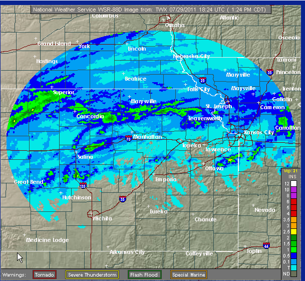
Valley Falls, KS had 2.35" of rainfall...here is a map showing the ground truth reports of rainfall totals...


Click on that map to make it larger...

There were some damaging storms with the acticity that was developing around 6-7PM near the Greenwood area on the MO side...this picture was taken by Vince our IT guy...who was in Greenwood at the time of the storm...


There are still some showers up to the north of the KC area, helping to reinforce the "coolness" of the air up there.

Meanwhile Tropical Storm Don continues to head towards the S TX coastline. The rainfall will be welcome for sure with rainfall deficits down there int he area of 9-18". Anything would certainly be welcome. Here is the latest picture on Don...


It's holding it's own with winds of 50-55 MPH...despite some northerly shear. The future of the storm has been pretty well predicted and Don will continue a nice WNW movement. The speed of the storms motion will preclude crazy rainfall totals...


The folks from HPC have issued this rainfall forecast...not exactly widespread but at least some will get more than a good dousing from the tropical storm...


Back to our weather...we should get a bit more of a temperature break tomorrow with hopefully the addition of more widespread cloud cover and maybe some additional rainfall. We'll need to watch tonight for the potential of another cluster of t/storms developing a bit farther southwards compared to last night. The cluster may develop closer to the I-70 corridor off to the west of here...there is clearly a vort max across the western part of KS but it's barely moving...so there are a few players on the field for additional rainfall tonight and even through part of the day tomorrow...

After that we'll once again jump right back into the heat with the high humidity again until we bake out the air, which will happen early next week. 95-100 degree heat is likely SUN-MON with the downtown area and points southwards between 100-105. So we'll once again be back into the same oppressive airmass that has settled to our immediate south today. Sometime later next week we'll do the whole thing again with a reduction in the highs and at least some chances of additional rainfall.


Have a great weekend!


Joe

Thursday, July 28, 2011

The Grinding Heat Eases Off

I'm back...spent about a week in the Phoenix area visiting my mom and playing a lot of golf, well mainly playing a lot of golf. Overall about 6 rounds in 5 days...each day was about 100-105 with dewpoints in the 40s and 50s...barely sweated at all. On Monday AM, after some nice t/storm activity Sunday night, it was rather thick there with dewpoints near 70 or so. It lasted for about 6 hours before the desert sun started to dry things out again. Didn't see any haboobs, but the folks there are still buzzing about them. As a matter of fact there was a big writeup in the Sunday paper about the phenomena. Anyway I'm back which means it's time to start the weather blogs again.

In my absence I see I didn't miss much...l00 degree heat has become common around these parts and even when we get a "break", perhaps like tomorrow and Saturday, we still expect 90s in the region to be the norm. Hopefully we'll take off about 5-10 degrees compared to the last several days. Over this weekend I'll be doing some comparison stats for you showing how this summer is comparing to last summer. We were really in the heart of the summer heat last year at about this time and it continued throughout the month of August before finally breaking. We finished last August some 4.6 degrees above normal and it appears that this August will certainly start out rather toasty as another run of 100+ heat appears to be shaping up.

This again is being generated by our semipermanent dome of heat that is recycling again through the middle part of the country. This will once again intensify across the midwest early next week and you can clearly see the effects on the temperatures around 5000' or so...
Now here is the same map for later int he week...there is a suggestion that there could be another weak front trying to slide our way...this is very iffy at this point...

So when things get this slow, I'm always looking to talk about something else...and today we'll tackle the tropics where Tropical Storm Don, which formed yesterday has had a rough go of things...first take a look at the latest satellite picture...


It's basically a ball of convection with winds near the center at close to 45 mph. There should be some intensifying as the storm is over the open waters of the very warm Gulf Of Mexico and the folks @ TPC suggest the potential for 60 MPH winds. The storm is also undergoing some shear, which is like poison to a tropical system. While not tremendous it may be enough to keep the intensification below hurricane status. As far as where Don should end up...latest forecasts have the storm near or just north of Corpus Christi sometime early Saturday morning. This actually may be a good thing down there, as is often the case in drought situations, and they really need the rainfall, these things sometimes will ease with tropical rainfall. I think I read the other day that this part of Texas needed some 15-20" of rainfall to catch up. Systems like Don can help that IF they slow down, which Don probably won't do. Can't imagine how much, if any, moisture will head this way...the dome of heat will deflect the moisture well to the south of here and then take it into far W TX or Southern NM...so at this point it doesn't look that promising.


Also of note is the record rainfall that has fallen in Chicago, several days ago, and also in Dubuque, IA yesterday with some 7.47"...very impressive. It would not be unusual that when this heat finally breaks here that some big t/storm complex will be generated...

Today is the 14th straight day @ KCI and 15th straight day @ the downtown airport that we've busted through 90 or higher...

Have a great day and it's nice to be back!

Joe

Friday, July 15, 2011

Slowly...but surely we're getting into it now...temperatures today are running several degrees warmer than yesterday at this hour...and it's a trend that will continue for the next week or so. With dewpoints in the 70-75 range creating a Heat Index of 100+ around the region. Areas to the SW of KC are even a few degrees warmer as Emporia will nudge to 100 this afternoon and for all the reasons talked about yesterday, it's tough to see 1) any significant rainfall and 2) any let-up in the unrelenting heat that will be broiling the midsection of the country for the next 7+ days. This graphic from the NWS explains/shows the latest heat headlines...


Really I don't think there is more that I can add to this...remember your heat safety tips, drink a lot of water and remember the elderly as well as the pets for the next 5-7+ days. What MAY give us some relief is the potential of a cold front before next weekend. That front doesn't look super strong, as one would expect during July, but hopefully it'll knock down the heat for at least a couple of days. Think about this some 25 million people are covered by Excessive Heat Warnings and Watches through 12 states

With all the sinking air being created by the hot air generator, pretty much on top of KS/MO...clouds will also become more and more scarce for awhile...that too will not help out the cause. Also don't be surprised, because of a lack of wind that air pollution (ground level ozone) becomes an issue early next week as well...


The terrain that didn't get the storm activity from a few nights ago is now starting to dry out in a big kind of way...take a look at this doppler estimated rain total from the last week and from the last 2 weeks, you can see areas just to the SW of KC proper are much drier than areas near and north of I-70.

The last 7 days...


The last 14 days...


I realize that in thumbnail form those maps are tough to read...click on them to make them larger...

This lack of moisture the farther to the S/SW you go certainly played a role in keeping KCI (officially for KC) below 100...and may help out again for a few more days...again IMO I'm targeting WED-FRI as potential 100+ (officially) for KC...unofficially this should happen from Downtown southwards perhaps as early as Tuesday...if not by Monday. Regardless, whether it's 98 or 103 it's still hot and really just a matter of semantics at this point. The humidity may start coming down a bit more by the middle of the week.

Our beloved Royals are up in Minnesota, where the heat will be expanding towards this weekend...I saw this article in the Washington Post...we need all the help we can get right!


Have a great weekend and try to stay cool!


Joe

Thursday, July 14, 2011

The summer doldrums have now arrived and it may be another week or so before we get to talk about better rain chances around these parts...the main focus will be on a developing heat wave that will encompass more terrain than the previous spell of hot weather...and this looks to last longer fueled be a strong area of High Pressure in the middle-upper part of the atmosphere and dry-drought conditions that continue to worsen across the southern plains states and slowly creeping up towards the SW part of the viewing area....

This will be a nasty stretch of highs, on average between 95-100 with 100+ readings again possible on the S/SW side of the viewing area. It will take another several days for the rainfall that fell to evaporate and this will take the form of higher dewpoints for awhile so that means the heat index will be nastier as well...hence the Excessive Heat Warning that just been issued this afternoon. This looks to last through the end of next week...there are hints in the modeling of a strong enough wave to move across the US/Canadian border later next week to drag a cold front through here before next weekend. Ahead of this front would be the hottest weather, with additional wind as well. By them the soil moisture will be sparse and with that wind, comes the risk of 100-105 degree highs "officially" @ KCI that is. The positive is that the dewpoints by then should be dropping into the middle 60s so the heat index values, still high, may actually be a bit lower. Overnight lows will be int he 75-80 range in the outlying areas to 80-85 range in Downtown KC...that's a bad combination for people who don't have A/C and have no opportunity to cool off, even at night.

Did you know that so far this year 9 people have died from heat related causes in the KC area...that's more people killed from the heat than from tornados and flooding combined for many years in the KC area. Interesting isn't heat. We, in the media, make sooooo much about the threat of tornados, that in reality it's the creeping and building heat that is a much more significant weather killer, on average for KC. Just something to think about...

The drought across the southern plains states continues to fester as well...take a look at this map showing the extent. This is from earlier this week...


Now let's focus into Texas where 72% of the state is considered in the "exceptional" category.


Farther north into southern KS and the drought has jumped the OK/KS line...take a look...


The reason for the coming heat is a large ridge developing through the atmosphere and centering itself across KS and MO...this dome of hot air will extend from the surface upwards of 20000'. The warmer air aloft will be sinking as well...as air sinks it heats up and this will make hot afternoons even hotter. Take a look at the GFS forecast for later next week...

That circle in the middle is the mature anticyclone that will be wobbling around for several days...the temperatures at that level will be near -5C which sounds cold, but then again you're talking close to 3.5 miles up...and in reality it's really not that cold for that level...as you come down it gets much warmer...take a look at the 5000' temperatures...for the same time frame...

If you remember LAST year from the 13th of July through the rest of month every day (except 4) were marked by highs in the 90-95 range and dewpoints in the high 70s and low 80s...it was awful. Then for the 1st 14 days of August we had 1 day in the 80s (89) and 3 in the 100s @ KCI including the 13th when we hit 103 for the hottest day since August of 2006...again nasty heat on top of nasty heat.

I just dug up some interesting heat related information from the MO Health Dept...

In Missouri, the greatest numbers of heat-related deaths have occurred in the urban, more densely populated areas of St. Louis City, St Louis County and Jackson County (Kansas City). Of the 231 heat-related deaths reported from 2000 through 2010, there were 140 (61%) deaths in these metropolitan areas. Rural deaths accounted for 91 (39%) of the deaths. Non-Missouri residents who succumb to heat while visiting are considered cases, accounting for 6 deaths. Hyperthermia Mortality by Geographic Area, Missouri 2000-2010 White males are the most frequent victims of heat-related illness resulting in death. In the same nine-year period, there were 113 (49%) white male deaths. Hyperthermia Mortality by Race and Sex, Missouri 2000-2010  

Slightly more than half 120 (52%) of the 231 deaths during 2000-2010 have been of people age 65 years and older. Victims in this population often live alone and have other complicating medical conditions. Also, lack of air conditioning or refusal to use it for fear of higher utility expenses contributes to the number of deaths in the senior population. There were 99 (43%) hyperthermia deaths occurring in the 5 through 64-year-old age group. These deaths often have contributing causes such as physical activity (sports or work), complicating medical conditions, or substance abuse. Circumstances causing hyperthermia deaths in young children often involve a motor vehicle—a child left in or climbing into a parked vehicle during hot weather. From 2000-2010, there were 12 (5%) deaths of children less than five years of age.

Missouri’s highest temperatures generally occur in July and August each summer. Thus, the majority of hot-weather-related deaths also occur during these months. Of the 231 deaths from 2000-2010, 97 (42%) deaths were during the month of July and 88 (38%) were in August. In 2010, 10 of the 17 hot weather-related deaths occurred in August. During August 2010, the heat index exceeded 100 in the majority of the state for a period of 7 or more days

Stay cool and remember your heat safety tips...you'll need them for another 7-10 days at least...

Joe

Monday, July 11, 2011

Damaging Derecho

Earlier this morning, while those of us in the Kansas City Metro were preparing for another 100+ degree day, many others in the upper Midwest dealt with a derecho causing all sorts of damage. For those of you who are unfamiliar with a derecho, the word derecho comes from Spanish and means "straight." In weather, a derecho describes a windstorm that is long-lived and often produces extended stretches of straight-line wind damage. Derechos are similar to gust fronts in the sense that their movement is in the direction of the thunderstorms they are associated with. Unlike a gust front, a derecho's winds are sustained and often increase in strength behind the "gust front." Derechos are a warm weather phenomenon found mostly in the summer months, however, they can occur at anytime during the year, day or night!

Here is a picture from the Storm Prediction Center showing the number of reports from this storm.

Damage reports from this storm tracked across Iowa and into Illinois. Winds were reported to be around 80mph and some places also experienced heavy rain, almost 2in in 24 hours! Damaged grain bins, significant tree damage, downed power lines, and power outages were also a result of this storm.
Damage near Cedar Rapids, IA (Photo courtesy of KCRG-TV)
  
If there is one group of people who may remember this storm, it would be the folks from WHO TV Channel 13 in Des Moines. Their radar was destroyed and parts of it (as shown below) was thrown into the yard of a nearby home.


Back to us here in the KC metro, it is just going to remain hot and humid. We are under an excessive heat warning until 7pm Tuesday. Drink plenty of water and stay in air-conditioned rooms whenever possible. If you find yourself outside, be sure take necessary precautions like wearing sunscreen and light colored clothing. If you are working outside, take frequent breaks in a shaded or air-conditioned environment.

Stay Cool!
Kristy